
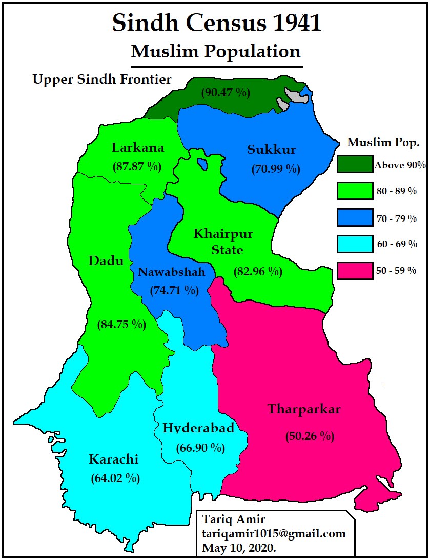
127. Demographics of Sindh Province According to the Census of 1941
In
October 2014, I wrote a post on the “Partition of Punjab in 1947” that proved to be the most popular of all my posts and drew the most comments
as well. Some of the friends from the other side of the divide argued that so
what if some Muslim majority Tehsils were awarded to India, as the same thing
happened in Sindh, where many Hindu majority districts were given to Pakistan. Some
other sources on the internet made similar observations and even made some
fantastic claims. Anyway, this subject remained high on my mind, and finally I
found all the details I needed, maps showing Talukas and census figures for the
year 1941, the last census of British India. At the end, you will find the
details of my sources.
The
post has two sets of maps; the first two maps show the population of Muslims and
Hindus in Sindh in 1941, district-wise, and the second set of two maps shows the
populations of the two communities, taluka-wise. Other communities, like Sikhs,
Christians, Jains, Parsees, etc. made up a very small proportion of the total
population. I
have tried to present the information in a simple way, and hopefully, readers
will find it easy and interesting to read the tables and the maps.
|
Census |
||||||||
|
No |
District |
Population |
Muslims |
% |
Hindus |
% |
Sikhs |
% |
|
01 |
Dadu |
389,380 |
329,991 |
84.75 |
58,372 |
14.99 |
630 |
0.16 |
|
02 |
Hyderabad |
758,748 |
507,620 |
66.90 |
245,849 |
32.40 |
3,669 |
0.48 |
|
03 |
Karachi |
713,900 |
457,035 |
64.02 |
222,597 |
31.18 |
7,589 |
1.06 |
|
04 |
Larkana |
511,208 |
418,543 |
81.87 |
91,062 |
17.81 |
1,549 |
0.30 |
|
05 |
Nawabshah |
584,178 |
436,414 |
74.71 |
140,428 |
24.04 |
5,778 |
0.99 |
|
06 |
Sukkur |
692,556 |
491,634 |
70.99 |
195,458 |
28.22 |
4,696 |
0.68 |
|
07 |
Thar Parkar |
581,004 |
292,025 |
50.26 |
247,496 |
42.60 |
6,815 |
1.17 |
|
08 |
Upper Sindh |
304,034 |
275,063 |
90.47 |
28,664 |
9.43 |
285 |
0.09 |
|
09 |
Khairpur State |
304,787 |
253,690 |
82.96 |
49,604 |
16.22 |
1,616 |
0.53 |
|
|
Total |
4,839,795 |
3,462,015 |
71.53 |
1,278,555 |
26.41 |
32,627 |
0.67 |


The
table given below provides the religious composition of Sindh Taluka-wise, a taluka is a sub-division of a district. The two maps show the population of
Muslims and Hindus accordingly.
|
No |
District/Taluka |
Population |
Muslims |
% |
Hindus |
% |
|
1 |
Dadu |
389,380 |
329,991 |
84.75 |
58,372 |
14.99 |
|
i |
Dadu |
62,476 |
53,038 |
84.89 |
9,318 |
14.91 |
|
ii |
Johi |
55,851 |
49,685 |
88.96 |
5,883 |
10.53 |
|
iii |
Kakar |
62,609 |
53,621 |
85.64 |
8,982 |
14.35 |
|
iv |
Kohistan Mahal |
23,801 |
21,058 |
88.48 |
2,741 |
11.52 |
|
v |
Kotri |
45,146 |
32,872 |
72.81 |
11,963 |
26.50 |
|
vi |
Mehar |
86,491 |
75,206 |
86.95 |
11,120 |
12.86 |
|
vii |
Sehwan |
53,006 |
44,511 |
83.97 |
8,365 |
15.78 |
|
2 |
Hyderabad |
758,748 |
507,620 |
66.90 |
245,849 |
32.40 |
|
i |
Badin |
78,835 |
65504 |
83.09 |
13,161 |
16.69 |
|
ii |
Dero Mohbat |
75,524 |
53551 |
70.91 |
21,810 |
28.88 |
|
iii |
Guni |
107,126 |
85,611 |
79.92 |
21,166 |
19.76 |
|
iv |
Hala |
116,615 |
91,744 |
78.67 |
24,343 |
20.87 |
|
v |
Hyderabad |
214,933 |
97,762 |
45.48 |
115,015 |
53.51 |
|
vi |
Tando Allahyar |
92,014 |
59,571 |
64.74 |
31,285 |
34.00 |
|
vii |
Tando Bago |
73,701 |
53,877 |
73.10 |
19,069 |
25.87 |
|
3 |
Karachi |
713,900 |
457,035 |
64.02 |
222,597 |
31.18 |
|
i |
Ghorabari |
21,827 |
20,402 |
93.47 |
1,327 |
6.08 |
|
ii |
Jati |
30,356 |
28,506 |
93.91 |
1,749 |
5.76 |
|
iii |
Karachi |
435,887 |
208,866 |
47.92 |
195,257 |
44.80 |
|
iv |
Keti Bunder |
9,248 |
7,346 |
79.43 |
1,325 |
14.33 |
|
v |
Mipur Bathoro |
45,493 |
38,824 |
85.34 |
5,795 |
12.74 |
|
vi |
Mirpur Sakro |
38,757 |
36,043 |
93.00 |
2,578 |
6.65 |
|
vii |
Shah Bunder |
39,681 |
36,002 |
90.73 |
3,450 |
8.69 |
|
viii |
Sujawal |
37,922 |
33,658 |
88.76 |
3,874 |
10.22 |
|
ix |
Tatta |
54,729 |
47,388 |
86.59 |
7,242 |
13.23 |
|
4 |
Larkana |
511,208 |
418,543 |
81.87 |
91062 |
17.81 |
|
i |
Kambar |
89,583 |
76,375 |
85.26 |
13,185 |
14.72 |
|
ii |
Labdarya |
82,058 |
66,778 |
81.38 |
15,042 |
18.33 |
|
iii |
Larkana |
103,018 |
74,772 |
72.58 |
27,434 |
26.63 |
|
iv |
Miro Khan |
45,870 |
42,197 |
91.99 |
3,542 |
7.72 |
|
v |
Rato Dero |
65,941 |
50,071 |
75.93 |
15,588 |
23.64 |
|
vi |
Shahdad Kot |
50,342 |
43,879 |
87.16 |
6,438 |
12.79 |
|
vii |
Warah |
74,396 |
64,471 |
86.66 |
9,833 |
13.22 |
|
5 |
Nawabshah |
584,178 |
436,414 |
74.71 |
140,427 |
24.04 |
|
i |
Kandiaro |
87,116 |
69,814 |
80.14 |
17,172 |
19.71 |
|
ii |
Moro |
72,899 |
61,374 |
84.19 |
10,120 |
13.88 |
|
iii |
Nawshahro Feroz |
103,806 |
84,539 |
81.44 |
18,971 |
18.28 |
|
iv |
Nawabshah |
76,250 |
54,561 |
71.56 |
19,859 |
26.04 |
|
v |
Sakrand |
67,626 |
59,403 |
87.84 |
7,243 |
10.71 |
|
vi |
Shahdadpur |
120,254 |
71,177 |
59.19 |
47,761 |
39.72 |
|
vii |
Sinjhoro |
56,227 |
35,456 |
63.06 |
19,294 |
34.31 |
|
6 |
Sukkur |
692,556 |
491,634 |
70.99 |
95,458 |
28.22 |
|
i |
Garhi Yasin |
79,426 |
65,602 |
82.60 |
13,502 |
17.00 |
|
ii |
Ghotki |
56,674 |
46,328 |
81.74 |
10,093 |
17.81 |
|
iii |
Mirpur Mathelo |
59,016 |
48,256 |
81.77 |
10,759 |
18.23 |
|
iv |
Pano Akil |
56,410 |
45,147 |
80.03 |
11,213 |
19.88 |
|
v |
Rohri |
95,365 |
63,447 |
66.53 |
30,172 |
31.64 |
|
vi |
Shikarpur |
151,878 |
101,561 |
66.87 |
49,774 |
32.77 |
|
vii |
Sukkur |
140,118 |
76,655 |
54.71 |
60,747 |
43.35 |
|
viii |
Ubauro |
53,665 |
44,638 |
83.18 |
8,998 |
16.77 |
|
7 |
Thar Parkar |
581,004 |
292,025 |
50.26 |
247,496 |
42.60 |
|
i |
Chachro |
74,727 |
31,791 |
42.54 |
35,103 |
46.97 |
|
ii |
Digri |
59,243 |
31,338 |
52.90 |
25,194 |
42.53 |
|
iii |
Diplo |
34,001 |
23,962 |
70.47 |
7,219 |
21.23 |
|
iv |
Jamesabad |
41,357 |
19,752 |
47.76 |
20,395 |
49.31 |
|
v |
Khipro |
64,494 |
36,774 |
57.02 |
27,112 |
42.04 |
|
vi |
Mirpurkhas |
68,973 |
30,840 |
44.71 |
37,234 |
53.98 |
|
vii |
Mithi |
46,698 |
20,333 |
43.54 |
15,201 |
32.55 |
|
viii |
Nagar Parkar |
32,458 |
12,980 |
39.99 |
15,629 |
48.15 |
|
ix |
Samaro |
51,511 |
26,285 |
51.03 |
20,182 |
39.18 |
|
x |
Sanghar |
40,027 |
29,080 |
72.65 |
10,394 |
25.97 |
|
xi |
Umarkot |
67,515 |
28,890 |
42.79 |
33,873 |
50.17 |
|
8 |
Upper Sindh |
304,034 |
275,063 |
90.47 |
28,664 |
9.43 |
|
i |
Garh Khairo |
47,554 |
45,245 |
95.14 |
2,296 |
4.83 |
|
ii |
Jacobabad |
63,307 |
52,814 |
83.43 |
12,236 |
19.33 |
|
iii |
Kandhkot |
75,481 |
69,429 |
91.98 |
6,021 |
7.98 |
|
iv |
Kashmor |
47,765 |
44,960 |
94.13 |
2,804 |
5.87 |
|
v |
Thul |
67,927 |
62,615 |
92.18 |
5,307 |
7.81 |
|
9 |
Khairpur State |
305,787 |
253,690 |
82.96 |
49,604 |
16.22 |
|
i |
Faiz Ganj |
24,036 |
21,860 |
90.95 |
1,862 |
7.75 |
|
ii |
Gambat |
85,816 |
71,109 |
82.86 |
14,117 |
16.45 |
|
iii |
Khairpur |
93,725 |
73,494 |
78.41 |
19,418 |
20.72 |
|
iv |
Kot Diji |
47,121 |
40,618 |
86.20 |
6,429 |
13.64 |
|
v |
Mirwah |
41,420 |
34,581 |
83.49 |
6,681 |
16.13 |
|
vi |
Nara |
13,669 |
12,028 |
87.99 |
1,097 |
8.03 |


|
No. |
City |
Pop. |
Muslims |
% |
Hindus |
% |
|
1 |
Karachi |
386,655 |
152,385 |
39.41 |
183,883 |
47.56 |
|
2 |
Hyderabad |
134,693 |
36,069 |
26.78 |
96,603 |
71.72 |
|
3 |
Sukkur |
66,466 |
8,152 |
27.31 |
46467 |
69.91 |
|
4 |
Shikarpur |
62,746 |
1,775 |
34.70 |
40,680 |
64.83 |
|
5 |
Larkana |
28,085 |
7,834 |
27.89 |
19,969 |
71.10 |
|
6 |
Jacobabad |
21,588 |
9,774 |
45.28 |
11,561 |
53.55 |
|
7 |
Mirpurkhas |
19,591 |
5,086 |
25.96 |
13,947 |
71.19 |
|
8 |
Khairpur |
17,510 |
9,639 |
55.05 |
7,786 |
44.47 |
|
9 |
Nawabshah |
17,509 |
4,420 |
25.24 |
12,048 |
68.81 |
|
10 |
Tando Adam |
17,233 |
2,994 |
17.37 |
14,049 |
81.52 |
|
11 |
Rohri |
14,721 |
4,132 |
28.07 |
10,460 |
71.05 |
|
12 |
Shahdadpur |
11,768 |
1,898 |
16.13 |
9,782 |
83.12 |
|
13 |
Kambar |
11,681 |
6,297 |
53.91 |
5,621 |
48.12 |
|
14 |
Dadu |
10,896 |
5,179 |
47.53 |
5,601 |
51.40 |
|
15 |
Kotri |
9,979 |
5,137 |
51.48 |
4,436 |
44.45 |
|
16 |
Ratodero |
9,925 |
2,393 |
24.11 |
7,942 |
80.02 |
|
17 |
Tando M. Khan |
8,718 |
2,902 |
33.29 |
5,748 |
65.93 |
|
18 |
Tando Allahyar |
8,406 |
1,690 |
20.10 |
6,622 |
78.78 |
|
19 |
Garhi Yasin |
8,397 |
2,278 |
27.13 |
5,426 |
64.62 |
|
20 |
Tatta |
8,262 |
4,198 |
50.81 |
4,054 |
49.07 |
|
21 |
Hala |
7,964 |
5,042 |
63.31 |
2,597 |
32.61 |
|
22 |
Matiari |
5,910 |
4,334 |
73.33 |
1,575 |
26.65 |
|
23 |
Ghotki |
5,236 |
1,533 |
29.28 |
3,701 |
70.68 |
|
24 |
Gambat |
4,893 |
1,989 |
40.65 |
2,897 |
59.21 |
|
25 |
Sehwan |
4,364 |
2,218 |
50.82 |
2,203 |
50.48 |
|
26 |
Umarkot |
4,275 |
986 |
23.06 |
3,218 |
75.27 |
|
27 |
Nasarpur |
3,610 |
2,331 |
64.57 |
1,279 |
35.43 |
|
28 |
Manjhand |
3,025 |
1,053 |
34.81 |
1,956 |
64.66 |
|
|
|
|
|
|
|
|
 |
| Cities & towns of Sindh. |
I
want to especially thank my friend Imran Javed for helping me in completing this
post. I found the census report of the Sindh province but it was not properly
scanned and was very difficult to read. Some pages were entirely missing. Here, Mr Imran came to my rescue and contacted the office of the Census Commissioner
of India and thankfully, they replied within 18 hours and provided the link of
their wonderful website with all the information I needed.
An
equally big hurdle was to find a map of Sindh, showing not only the
boundaries of district but the talukas as well. I found the following two links
very helpful and the maps are based on these two sources.
https://southasiablog.wordpress.com/2014/11/07/why-wasnt-sindh-parititioned-in-1947/
https://www.citypopulation.de/php/pakistan-distr-admin.php
I
have tried to be as accurate and objective as possible. The statistics are
accurate, taken from the official website of the Census Commissioner of India,
but the maps can be in need of some improvement. However, any inaccuracy is unintentional
and will be corrected if found to be contrary to the facts. I hope readers who have an interest in this subject will find it useful.
Tariq Amir
May 14, 2020.
Doha – Qatar.
For related posts, visit:
035. Partition Of Punjab in 1947
036. Muslim Population Of India: According To The Censuses Of 1941 and 2001
037. Partitions Of Bengal in 1905 and 1947
054. Muslim Population Of India: According To The Census of 2011
128 – Demographics of North West Frontier Province According to the Census of 1941
129 – The Disputed States I : Jammu & Kashmir (Demographics 1941)
130 – The Disputed States II: Hyderabad State (Demographics 1941)
133. Demographics of Balochistan Province According to the Census of 1941 (Religions)